Supervisorial Districts
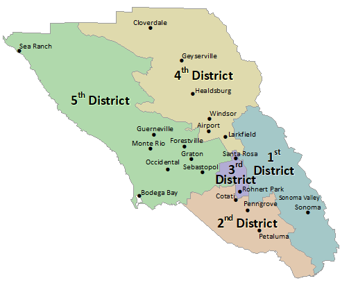
Supervisorial Districts Map
Supervisorial Districts
Board of Supervisors - District 1
The 1st Supervisorial District is bounded on the north by Porter Creek and Franz Valley School Roads, to the east by the Napa county line, to the west by a combination of roads, including Mark West Springs Road, Fountaingrove Parkway Brookwood Ave, Farmers Lane and Petaluma Hill Road, and to the south by San Pablo Bay.
Board of Supervisors - District 2
The 2nd Supervisorial District includes all of the cities of Petaluma and Cotati and a portion of Rohnert Park, as well as the unincorporated communities of Penngrove, Two Rock, Bloomfield, and a portion of the unincorporated community south of Sebastopol.
Board of Supervisors - District 3
The 3rd Supervisorial District is bounded on the north by Steele Lane, to the east primarily by Petaluma Hill Road, to the west by a combination of roads, including S. Wright Road, Llano Road, and Highway 101, and to the south by East Cotati Ave to Sonoma State University.

Board of Supervisors - District 4
The 4th Supervisorial District includes northeast Fulton, the Larkfield-Wikiup area of Santa Rosa, the Town of Windsor, the City of Healdsburg, the community of Geyserville and the City of Cloverdale.
Board of Supervisors - District 5
The 5th Supervisorial District encompasses the west county, including the entire Sonoma County coast, the lower Russian River area, Sebastopol, and portions of northwest and southwest Santa Rosa.