 Translate
Riparian Corridor (RC) Combining Zone
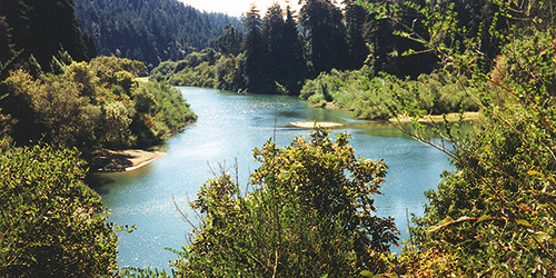
A Riparian Corridor is the area that encompasses a river or stream and the land adjacent to it. Riparian Corridors provide numerous benefits to the community and the environment such as improving water quality; increasing groundwater recharge; providing flood protection; enhancing wildlife and aquatic habitat; and supporting the recovery of salmon, steelhead and other endangered species.
In 2008, the Board of Supervisors adopted General Plan 2020 (GP2020) which increased protections for riparian corridors. In November 2014, the Board of Supervisors adopted zoning code changes to implement the stream protection policies and rezoned properties to add the Riparian Corridor (RC) Combining Zone to all designated streams shown on the General Plan Open Space maps.
Ordinance
Purpose
The Riparian Corridor (RC) Combining Zone is established to protect biotic resource communities, including critical habitat areas within and along riparian corridors, for their habitat and environmental value, and to implement the provisions of the General Plan Open Space and Resource Conservation and Water Resources Elements. These provisions are intended to protect and enhance riparian corridors and functions along designated streams, balancing the need for agricultural production, urban development, timber and mining operations, and other land uses with the preservation of riparian vegetation, protection of water resources, floodplain management, wildlife habitat and movement, stream shade, fisheries, water quality, channel stability, groundwater recharge, opportunities for recreation, education and aesthetic appreciation and other riparian functions and values.
Zoning Maps
- Planning Area 1 - Sonoma Coast / Gualala Basin
- Planning Area 2 - Cloverdale / Northeast County
- Planning Area 3 - Healdsburg and Environs
- Planning Area 4 - Russian River Area
- Planning Area 5 - Santa Rosa and Environs
- Planning Area 6 - Sebastopol and Environs
- Planning Area 7 - Rohnert Park-Cotati and Environs
- Planning Area 8 - Petaluma and Environs
- Planning Area 9 - Sonoma Valley