 Translate
Land Surveyor
A third party land surveyor, as opposed to the County Surveyor, is involved with measuring properties and pieces of land to determine boundaries. This information helps with the following:
- Determine where roads or buildings will be constructed.
- Settle property line disputes.
- Lead to the creation of maps.
What Do They Do?
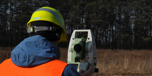
A land surveyor takes precise measurements to identify the boundaries of a parcel of land and prepares reports, maps, and plots that are used for construction, deeds, or other legal documents.
The precise location of roads, buildings, and other features that are used to determine any changes to the property line, restrictions on what may be built on a property or where new structures must be located, how large structures may be, and the appropriate building depths for foundations.
Existing corner records, records of survey, and maps are used by a land surveyor to help locate your property line/corners, and other survey related monuments.
When Does Land Need to Be Surveyed?
If you plan to construct a new building or structure on your property, you may need a land survey to identify the precise boundaries and any potential restrictions.
There might be easement for a service company’s such as electric company, water, or sewer company with right to access a portion of your property.
How Do I Find a Land Surveyor?
California Land Surveyors Association
Find a Surveyor
How Do I Choose a Land Surveyor (Brochure) (PDF)